


![]()
in 2017, The Yolo-Solano AQMD (District) launched their Community Air Sensor Program (CASP). This program installs low-cost sensors in under-served and rural communities throughout the District to provide residents and staff with real-time particulate matter (PM2.5) conditions on a daily and exceptional event basis. In addition, the program partners with local agencies and hopes to educate the public on the health impacts of wood smoke and how to access the information from these sensors.
The Community
Prior to the program, the District operated air monitoring equipment in four cities: Woodland, West Sacramento, Rio Vista and Vacaville. The equipment at these sites checked for PM2.5, PM10 or ozone. In addition to these four sites, CARB operated a fifth site in Davis on the UC Davis campus.
Over the years, the District has received comments and inquiries from residents interested in local PM levels and learning about the health impacts of particulate matter, especially as more wildfires have been impacting the area, such as the Napa and Sonoma wildfires in 2017 and the County Fire and Mendocino Complex fires in 2018 and most recently the LNU Fire in 2020, that directly burned within the District boundary.
As a result of the recent wildfire impacts and the concerns of residents, the District took the initiative to research and create a pilot program that would install air sensors throughout the District to check and relay particulate matter levels immediately on an open-sourced website for public consumption and inquiry.
Sensor Locations
The community’s concerns have helped shape and guide this program as well as its implementation. Unhealthy conditions impact everyone, regardless of population, demographic, or location and the public’s health is always at the forefront of the District’s mission. By installing a network of sensors in under-served locations, the District is investing in meaningful community involvement, strengthening relationships with local agencies, and supporting local interests with those that live and work in these areas.
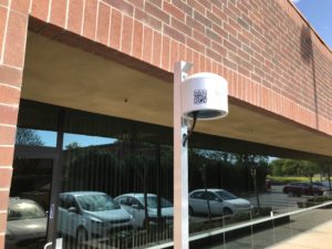
The District purchased a number of PurpleAir sensors that use laser particle counters to provide real time measurements of PM. The PurpleAir sensors use Google services, for scripting and mapping, and the Cloud, which uploads readings every 80 seconds on the PurpleAir map. These sensors are easy to install and require a power outlet and Wi-Fi.
So far, the District has placed these PurpleAir sensors in the following locations:
- Clarksburg
- East Woodland
- Esparto
- Guinda
- Madison
- Plainfield
- South Davis
- Vacaville
- Winters
The District continues to expand their sensor capacity and will be installing additional air sensors in the near future. Please check back for updates.
PurpleAir Map
The sensors are currently tied to the PurpleAir online platform where you can view and track sensors by city or zip code. You can also view current conditions for other sensors worldwide. Each sensor has a number and color correlating to the AQI (Air Quality Index) chart. This number and color will change as the air quality changes.
Please note that PurpleAir sensors are a good way to track trends in air quality related to particulate matter, i.e. air quality is getting worse or better, and they provide a general idea of the PM readings in the area near the community sensor. However the sensor may register higher numbers than what the air quality actually is and readings from these sensors currently can’t be used for official pollution statistics/data.
Once you are on the website, type in your zip code or city and state in the search bar, located in the top left corner. Additionally when accessing this data, it is advisable to switch the option in the Map Data Layer dialogue box in the lower left hand corner from “None” to “AQandU”. This will apply a correction factor that will make the readings relate more closely to the official air quality data. You can also click on a specific colored circle for additional data.
Health Impacts
PM is one of the criteria pollutants that the state of California and the U.S. EPA tracks and one of the most common sources of PM is wood smoke, such as from wildfires or wood burning done at a residence (i.e. in a fireplace, wood stove or fire pit). Wood smoke contains fine particulate matter (PM2.5), black carbon, toxic air contaminates and greenhouse gas emissions.
PM2.5 is especially harmful to human health because its smaller size, about thirty times thinner than a strand of hair, can easily bypass the human body’s natural defenses and travel to the lungs causing short term health effects, like coughing and sneezing, and worsen existing conditions, such as asthma and heart disease. These fine particulates can cause breathing problems for many residents, such as the young and elderly, and exacerbate existing conditions for those with respiratory ailments. Many people don’t realize that if you smell smoke, you’re breathing it.
To learn more about the health impacts of particulate matter, please click on the following links: